Two Yarra Bookends
This article was first published in the White Hat
Melbourne Newsletter No.205 on 8 February 2007

“On the left” said the amplified commentary “is where John
Batman stepped ashore and said ‘this will be the place for a village’.”
The commentary continued all the way to Williamstown. Most of it was wrong
but it still gave the casual visitor to Melbourne a rough feeling for the
place and its European settlement. The commentary was wrong because, for
much of the route from Richmond to the river mouth we were not travelling
along the Yarra River as known by the Aborigines and early European
Melburnians. - we were travelling along a man-made channel now called the
Yarra River while much of the original river has been filled in. The
re-routing of the river resulted partly from flood-control works and partly
from major dock works. One result was that some islands became part of the
‘mainland’ while, at least in one case, a piece of the mainland became an
island.
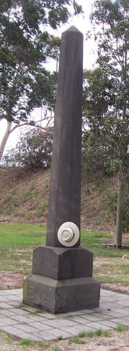
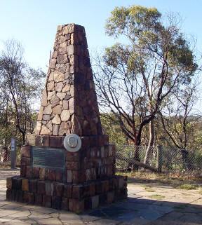
Two monuments for us act as bookends to the Yarra of early Melbourne. Few
people notice them and even fewer read and ponder them. The first (see left)
stands near the original junction of the Yarra and the Maribyrnong and
announces that the rivers were ‘discovered’ by Charles Grimes in 1803 and
later ‘refound’ by John Batman in 1835. I sometimes ponder how you explain
to a local Aborigine whose people had known these rivers for thousands of
years what those words carved into the granite mean.
Charles Grimes had been sent from Sydney to reconnoitre the area and warn
off the French who it was thought may lay claim to this so-called Terra Nullius.
Having encountered the French at King Island and deciding they were not
about to subvert the colonies he went on to examine the nooks and crannies
of Port Phillip Bay. Charles Grimes and his party made their way up the
river in a heavy rowboat - no easy task given that the river was clogged
with snags and fallen trees. They passed the river junction where the
monument now stands and proceeded until they encountered ‘The Falls’ where
the Queen Street Bridge now stands. Grimes recognised that this natural
barrier prevented the salt water from the bay from travelling further
upstream and thus offered a prospective settlement with a natural source of
fresh water. It is this place which we believe he declared "The most
eligible place for a settlement I have seen is on the freshwater river".
He also recognised that if he was to explore further upstream the party
would meed to haul the heavy boat out of the water and manhandle it to the
other side of the falls. “Bother” said Grimes - or nautical words to
that effect. They followed the meandering river through the now Botanic
Gardens (the lake in the gardens was part of the original
 Yarra)
through the now suburbs of Richmond, Fitzroy and Abbotsford until they came
across another river junction and set of rapids now known as Dight’s Falls.
At the prospect of hauling the boat across that next set of falls without
knowing whether there was yet another just around the corner, Grimes said
“double bother” and decided to investigate the local area before turning
back.
Thirty-two years later, John Batman was to make his way up the river and
further up the Merri Creek is where we believe he said "This is the place
for a village". Had this prediction proven correct then downtown
Northcote would now be our CBD. It possibly also explains why the large
plaque in the footpath on the corner of Flinders & Williams Streets implying
that was the place Batman was referring to has quietly disappeared. However
if you poke around in the bushland of Studley Park you will find a monument
commemorating the extent of Grimes’ journey.
As stated earlier, these two monuments are rarely noticed,. However for
us they form a pair of bookends for the early European exploration and
understanding of the Yarra
|
|
Copyright © 1995 - 2026
White Hat.
|
Other articles in the series Seven Monuments of Melbourne: